| Blood Border | |
| |
| Geographic Information | |
| Type | Borderlands |
| Region | Western Libaterra |
| Political Information | |
| Faction(s) | Crimson Coalition, Rebels |
| Historical Information | |
| Age | Third Age |
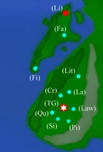
The Blood Border is a colloquial name given to an area which separated Rebel lands in the west from the Heartlands ruled by Locken Loyalists during the Libaterran Civil War. The Glory's Arm mountain range effectively seals the Blood Border by blocking off Rebel towns from the rest of Libaterra.
See also
| Libaterra | |||||
|---|---|---|---|---|---|
| Blood Border: | Crescena · Faithless · Finity · Lantis · Lawfin · Libermata · Lithe · Pilanthas · Quantas · Sirum · Trinity Gask | ||||
| Celenian Forest: | Illunii · Windshii · Xandir | ||||
| Fraquid Territories: | Gormin · Luma · Medina | ||||
| Heartlands: | Alent (Lutherin) · Amefuri · Ciano · Etheril · Forgan · Hidefall · Koutsuu · Naokin · Reign · Ridgefort · Rivalin · Solinas · Steelfall · Ukrainia | ||||
| Simoe Gorge: | Diduma · Faerine · Opinim | ||||
| Tronin Desert: | Daninka · Dosha · Kilm · Ruknir · Urimna · Vanna · Yunefas · Xibalba | ||||
| Other locations: | Kirsa · Malperdy · Sanctuary · Temple of the Unknown God · Troldhaugen | ||||
| Regions and Geography: | Blood Border · Celenian Forest · Drachian Forest · Dreamer's Death · The Eyes · Glory's Arm · Harvor Island · Ranger's Despair · Simoe Gorge · Snake Forest · Sun Shadow Forest · Survivor's Woods · Traquine · Tronin Desert · Undertide Forest | ||||